If you’re a brand new city, what can you do quickly to make your residents’ lives better? Peachtree Corners, one of Georgia’s newest cities, went digital—digitizing its resources to more efficiently manage its operations and make the public safer.
At the Council, we often get asked what cities can do to get started on a smarter journey. One good first step is to look for manageable first projects that can deliver an easy win and demonstrate a solid ROI. And as Peachtree Corners demonstrates below, digitizing your assets does all that and more. — Jesse Berst
By Brandon Branham, CH2M
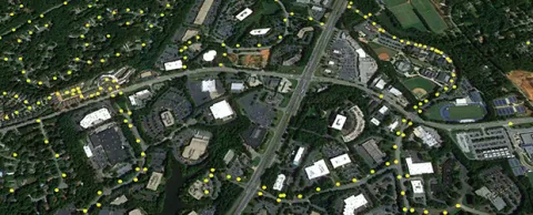
Roads, rights-of-way, signage and other built and installed assets require substantial staff resources to administer. And when a new city is incorporated, like Peachtree Corners, Georgia, the task can be monumental. This newly-formed city needed to identify all of its assets located in rights-of-way, but was relying on outdated data from the county. They needed a fast, accurate and economical tool to assist with asset inventory and analysis.
Innovative technology provides new options for managing assets
Municipal governments now have more technology options available to successfully manage their assets. For Peachtree Corners, CH2M applied photo imaging and LIDAR (surveying technology that measures distance by illuminating a target with a laser light) to compile a comprehensive asset catalog for the city to help refine and focus its management strategy.
Although this technology had been used to produce aerial views for years, no jurisdiction in Georgia had used it from the ground level. Thanks to this innovative and relatively new process, the city is “capturing” all of its assets and using the technology to design road projects, sidewalk projects and create asset replacement schedules. Residents can also use the data via a geographic information system (GIS) to view street-level imagery and see where the municipality’s assets are relative to their property.
Strategically placed street lights will enhance walkability, safety
In addition to capturing the city’s assets, CH2M is kicking off a street light enhancement program with Peachtree Corners this year that will use LIDAR data to locate areas where there are currently no street lights. Based on the information that is gathered, the city plans to install street lights to enhance walkability and safety for its residents and visitors.
Geospatial programs help cities provide quality service to citizens
GIS technology provides vital support for almost everything a local government does. Well-defined geospatial programs help cities like Peachtree Corners provide quality service to citizens in a cost-effective manner. Local government geospatial programs support a wide variety of functions including:
• Community Development (3D visualization, capital improvement planning, citizen participation, land-use analysis, sustainability initiatives, zoning efforts)
• Economic Development (affordable housing, special district assessments, job creation, business retention and attraction)
• Environment (air quality improvements, endangered species and environmental protection, regulation, site remediation, disaster response, stormwater management)
• Public Works (vehicle routing for inspections, trash pickup and snow plowing, parks management, permitting, work order management, infrastructure management)
• Revenue (impact and impervious surface fee assessment, property tax assessment, revenue projection)
• Transportation (mass transit management, congestion management, demand modeling, infrastructure design and maintenance, capital project management)
• Utilities (asset management, call-before-you-dig programs, demand forecasting, dispatching, outage notification and response, broadband mapping)
The Peachtree Corners asset inventory project is complete and 35,000+ assets were captured in rights-of-way — more than double what the city thought it had. The city is surprised by the amount of data it is receiving and is benefitting from the value innovative geospatial technology is providing.
Brandon Branham is the Project Manager/Finance Director for the City of Peachtree Corners, Georgia and has served this community since its opening in January 2013. Mr. Branham has been an employee of CH2M’s Operations Management group for 8 years and brings nearly a decade of local government experience in accounting, revenue and administration. In his role as Project Manager/Finance Director for the City of Peachtree Corners, he is responsible for the delivery of service across multiple departments, including Finance, Administration, Public Works, Planning & Zoning, Communications and Code Enforcement.
Smart Cities Readiness Guide ….
Use the Council’s Smart Cities Readiness Guide as a resource to plan your smart cities initiatives, build business cases for them, implement solutions and track your progress. It’s a free resource that helps you leverage digital technologies to make your city more livable, workable and sustainable.