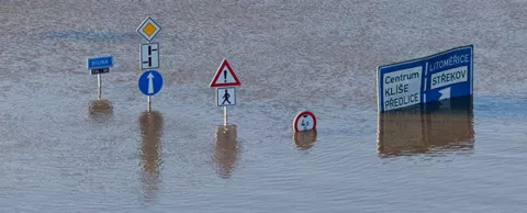
New projections for climate-change induced coastal flooding in the U.S. have a best-case and worst-case scenario, but even the best outcome isn’t very good. Hundreds of communities are past the so-called point of no return, which means that at least some severe flooding is now a given. The smart ones are making preparations today.
The new study, published in the Proceedings of the National Academy of Sciences, finds that 414 U.S. cities will experience severe flooding due to rising sea levels, even if we make sharp reductions to carbon emissions. That's the best case.
In New Orleans, 98% of the city would be under water. Again, that’s the best case.
Map brings data to life
Climate Central has developed maps that help planners visualize that data, showing how any U.S. community would fare under five scenarios, ranging from extreme carbon cuts to business as usual.
For instance, if we cut emissions sharply, Boston’s international airport could one day be an island. If we don’t, it will eventually be under water like much of the rest of the city.
There is some hope for New York’s lower Manhattan Island. With extreme carbon cuts, much of the island can be saved. Without, one day people will be diving to see the ruins.
It’s not clear when the flooding will happen -- it could be 200 or 2,000 years -- but the grim outlook should help inspire leaders to begin taking action now. The map shows permanent flooding. Some communities have already been affected by severe temporary flooding during super storms, like Hurricane Sandy.
Communities taking action now
On a short term basis, emergency planners are using detailed surge maps to guide their preparations during severe storms. The U.S. Army Corps of Engineers is updating its maps using higher-resolution modelling and topography so it can better understand what is actually at risk in various types of storms, allowing it to improve its public education efforts and to make better use of its resources.
Some communities are also working on projects to try to hold back at least some of the water.
New York is considering a giant levee -- four miles long and 20 feet high -- to protect Staten Island. The project is partially funded already. If it's built, it would be strong enough to protect the island against a severe one-in-300-year storm. Another proposal would protect 10 miles of low-lying land on Manhattan Island from storms and rising water, in part, by turning some of it into a greenbelt.
Miami Beach is in the midst of a five-year plan to raise roads and update its drainage infrastructure. Its proactive approach has drawn the attention of the federal government, even inspiring a visit from President Obama.
Going green -- not grey
The temptation in any flooding plan is to build the biggest wall possible, but that may not be wise. Those walls, known as grey infrastructure, can also trap water where you don’t want it, making flooding even worse.
Copenhagen is a coastal city that’s preparing by going green. Its plans call for engineering streets so they essentially turn into rivers during serious floods, directing water away from property and into the harbor. It wants to lower a lake so it can be used as a reservoir during storms. Green roofs and pavement that lets water percolate through are also part of its plan.
Even though the worst of the flooding may not happen for hundreds of years, Copenhagen wants to be ready by 2033. From a financial and sustainability perspective, it says “it makes sense to do as much as possible as early as possible.”
More stories …
Coastal cities getting smarter about flood control
Smart cities researchers simulate human behavior during floods